TYSOE ONLINE

  • About Tysoe
  • News
  • Events
  • Join In
    • B
      • Tysoe Band of Bell Ringers
      • Tysoe Indoor Bowls Club
    • C
      • The Tysoe Church Restoration Fund
      • Community Choir of Oxhill, Tysoe and Shenington
      • Cotswolds National Landscape
      • Craft & Laugh
      • Tysoe Community Hub
      • Tysoe Kurling Club
    • D
      • Tysoe Dance Exercise Class
    • F
      • Tysoe Flower Show & Fete
      • Tysoe Football Club
    • H
      • Tysoe Heritage Research Group
    • L
      • Tysoe Lunch Club
    • R
      • Tysoe & District Record
    • S
      • St Mary’s – Parish of Tysoe with Oxhill & Whatcote
      • Tysoe Social Club
      • Tysoe Community Speedwatch
    • T
      • Tysoe Tennis Club
    • U
      • Tysoe Utility Estate
    • V
      • Tysoe Village Hall
    • W
      • Tysoe Wildlife
      • Tysoe Wombles
      • Tysoe Women’s Institute
      • Wot2Grow Community Orchard CIC
  • Parish Council
    • Parish Councillors & Parish Clerk
    • Parish Council Meeting dates
    • Meeting Minutes & Documentation
    • Financial information
    • Local Planning
    • Neighbourhood Plan (2018-2021)
    • Policies & Procedures
  • Tysoe History
    • Old images of Tysoe
    • Projects
    • Village History
    • Guides
    • Tysoe Record
    • Miscellaneous Publications
    • Links to other websites
  • Contribute
  • Contact us
  • Subscribe

About Tysoe

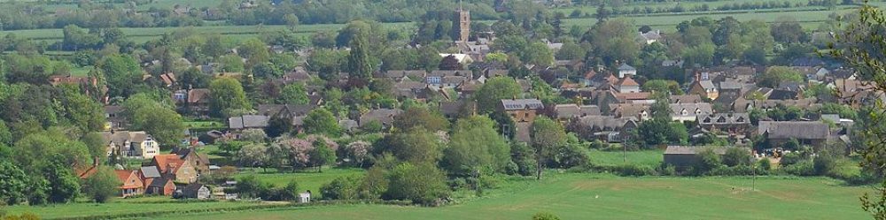
Tysoe Landscape

Tysoe is a rural parish in south Warwickshire, England. The parish comprises the main settlements of Upper, Middle, and Lower Tysoe, which are closely linked, geographically and historically.

Located about 7.5 miles northwest of Banbury, it is a rural area in the Vale of the Red Horse, with a clay substrate valley floor and a steeply rising escarpment to the east which forms part of the Cotswolds’ Area of Outstanding Natural Beauty (AONB).

The area has historical significance, once featuring a large “Red Horse” cut into the red clay hillside, though this has since disappeared although the Red Horse still provides an emblem for the Health Centre, the School, the junior football team and local businesses.

Much of the rich heritage of the area has been documented by the Tysoe Heritage Research Group. The 2011 Census recorded the population at 1,143, with a current estimate of around 1,200 people. Residents value its rural nature and were involved in creating a Neighbourhood Plan to guide future development, driven by Tysoe Parish Council.
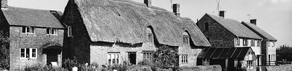
Old picture of Tysoe

Recent planning efforts have focused on managing development while preserving the village’s historic and rural character, with policies addressing housing, employment, and the environment.

Local services include a variety of trades, village shop, post office, church, public house, primary school and a satellite doctors’ clinic.

There is much to see, do and become involved in, more of which is shared in the What’s On area of this website.

WHAT’S NEW

Natural Burial Ground’s Annual Open Day

Events,News 10 May, 2026

Gentle Jazz in the Garden

Events,News 10 May, 2026

St Mary’s Church Concert

Events,News 8 May, 2026

Tysoe Parish Council – 2026 AGM

Events,News 5 May, 2026

Village Open Day

Events,News,Parish Council 27 April, 2026

Parish Council – wildflower management

News,Parish Council 22 April, 2026

Tysoe Parish Council

Tysoe Parish Council is the first tier of local government for the civil parish of Tysoe, Warwickshire

  • Parish Councillors & Parish Clerk
  • Parish Council Meeting Dates
  • Meeting Minutes
  • Financial Information
  • Local Planning
  • Neighbourhood Plan (2018-2021)
  • Policies & Procedures

Join in – Get Involved

Tysoe is bursting with organisations, volunteering opportunities and events. Come and get involved!

  • Join in
  • Contribute
  • Contact us
  • Site map
  • Events
  • News

Subscribe To Our Newsletter

  • Keep on top of the latest news and events, via a maximum of one email a day, and unsubscribe at any time
Subscribe

Cancel or pause any time.

Smartphones capturing a scenic wildflower meadow with trees
Facebook logo
  • Accessibility
  • Disclaimer
  • Site map
  • Privacy Policy
  • Subscribe